Hurricane Rita threatened the Houston area in September 2005. A mandatory evacuation was declared for the area where I live. I thus left town around 4:15 PM CDT on 9/21/05 for Fort Worth, Texas to the north. The local news implied it would be better to take a route other than the direct route up interstate 45 which would have been a trip of approximately 300 miles. I thus took a different route up state highway 146 which ended up being about 360 miles. I finally arrived in Fort Worth about 11:15 AM the next day.
The route consisted of about 30 minutes driving around the Clear Lake City area looking for gasoline (none found) and 15 minutes wasted when I took a wrong turn leaving town and had to back-track. Once on the road for real I took the following route:
Despite what the news reports implied, there was nothing faster about the chosen route and the drive turned into a 19 hour ordeal. The following plots show the trip in painful detail. The data for these plots was recorded using a Davis CarChip E/X OBDII recorder which stored the vehicle speed every five seconds.
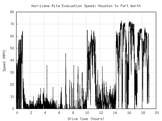
The first plot shows speed vs. time for the duration of the trip. Because of the side excursions, the trip really didn't get underway for nearly an hour after driving started. Almost immediately the traffic came to a standstill and remained that way for 9 hours until Dayton, Texas was reached. The "official" route at this point went north on state highway 321 which looked to also be crawling along. Instead I took a different route through Liberty starting at the 10 hour point in the plot. The route was longer but there were few cars and it was possible to drive at the posted speed until rejoining the pack at Livingston a bit after hour 11. US 59 was moving better than 146 earlier so it took only 3 hours to cover the 22 miles to US 287. From that point on there were few delays and progress was reasonable for the rest of the trip except when driving around Palestine in confusion about hour 16 and the stort stretch on I-45 at hour 17 where progress was once again slow.
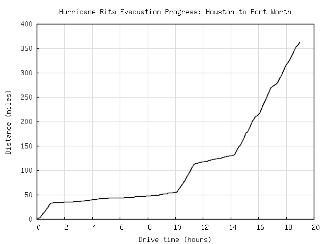
It is easier to see the rate of progress in the second plot. Here the distance traveled is compared to the time required. Again, quite a bit of ground was covered in the first hour but it contributed little in reaching the final destination. It took approximately 9 hours to drive the initial 33 mile segment along highway 146. The slow stretch along US 59 is visible from hours 11 to a bit past 14 and the bit on I-45 is around hour 17.
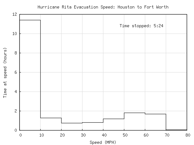
The last plot is a histogram showing how much time was spent at various speeds. More than half the trip was spent at speeds between 0 and 10 miles per hour. Almost half of that time (5:24) was spent stopped.
A surprising thing about the trip was how little gasoline was required when idling in traffic. I started the trip with slightly more than 3/4 of a tank of gas. By the time I filled up at Groveton, Texas (about 13 miles after getting on 287) the car still had slightly more than a quarter of a tank left. Thus, in over 13 hours of "driving", the car used about 7.5 gallons. For information on the gas mileage my car gets under more normal circumstances, see my BMW 318ti fuel economy page. On the plot on that page, the tank of gas used during most of the evacuation is visible as the point with an average speed of 11.9 MPH.
| Return to Home Page | Last updated: September 26, 2005 |